

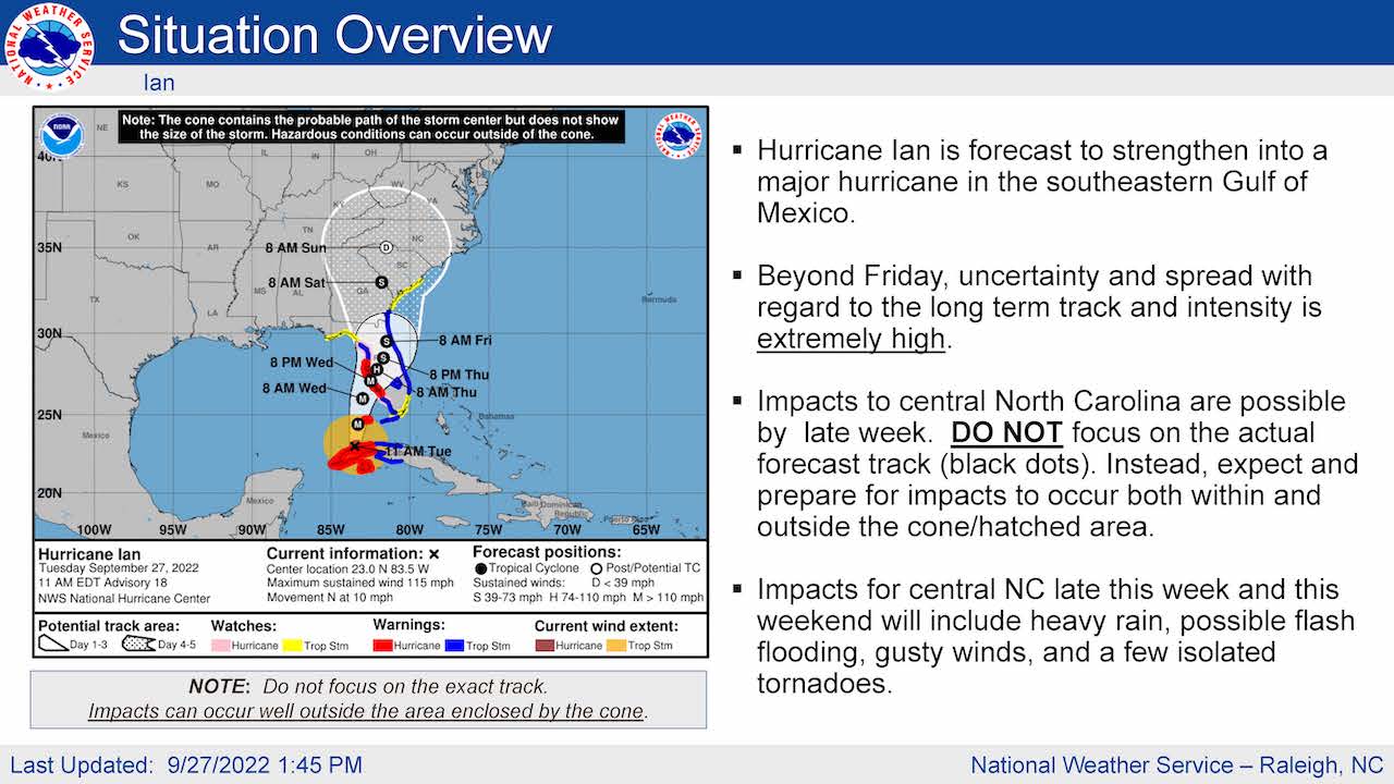
Hurricane Ian is now forecast to strengthen into a major hurricane in the southeastern Gulf of Mexico, the National Weather Service Raleigh bureau reported in its afternoon update.
Beyond Friday, the agency reported, uncertainty has spread about Ian’s long-term track and intensity.
The NWS expects central North Carolina impacts are possible late this week and those impacts are expected to take the form of heavy rain, possible flash-flooding, gusty winds and a few isolated tornadoes.
There is a minimal potential for damaging winds across parts of central North Carolina, the NWS said, however wind gusts of up to 40 miles per hour are expected Friday through Sunday.
Three to 7 inches of rain could result in localized flash-flooding of streams, creeks, urban areas and other low-lying areas prone to flooding. That could occur late Friday through Sunday.
The NWS said there is a small risk for level 1 tornadoes south and east of Raleigh. There is also a minor risk for river flooding across central North Carolina Sunday and into early next week.
The weather service says currently there is a two in 10 chance that central North Carolina could experience tropical force winds — mainly in gusts — late this week and into the weekend. The earliest arrival is during the daylight hours Friday.
Late Friday through Saturday is when the wettest and most impactful period of the storm is expected.


Meanwhile, the North Carolina Department of Public Safety said the state is preparing for heavy rainfall and possible flooding on Friday and Saturday from the remnants of the storm.
"While we don't yet know exactly how this storm will impact our state, it's clear that this will be a significant rain event for much of North Carolina and now is the time for people to get prepared," said Governor Roy Cooper. "We are tracking the storm closely and strongly encourage everyone across the state to have an emergency kit and emergency plan in place."
The State Emergency Response Team will activate Thursday at the State Emergency Operations Center in Raleigh and plans to move to 24-hour operations on Friday morning.
“We are coordinating with our partners in government and the non-profit and private sectors to make sure we are ready to support local communities through whatever Ian brings,” said State Emergency Management Director Will Ray.
Residents are advised to stay aware and keep a close eye on the forecast for the next several days. With each passing day, Ian’s expected impacts to North Carolina become clearer.
Rain chances will increase across southeastern North Carolina Thursday night, with the most widespread rainfall expected on Friday and Saturday. Much of North Carolina is forecast to see 2-5 inches late this week and weekend, but 5-7 inches or more will be possible near the coast and along the Blue Ridge Escarpment.
State officials advise these tips to make sure your family is personally prepared:
Have multiple ways to receive emergency info, including watches and warnings. Make sure emergency alerts are enabled on your cell phone and download a weather app.
Have an emergency plan. Know where you would go if you need to evacuate. Make a plan to stay with family, friends or at a hotel. Public shelters should be a last resort.
Gather some emergency supplies or refresh your emergency kit. Visit ReadyNC.gov for info on how to build an emergency kit.
If you live at the coast, you should know if you live in a coastal evacuation zone. Visit KnowYourZone.nc.gov to see if you are in a pre-determined evacuation zone. Learn your zone and listen for it if evacu


